Nocturnal Owl Survey - Newfoundland and Labrador

Picture
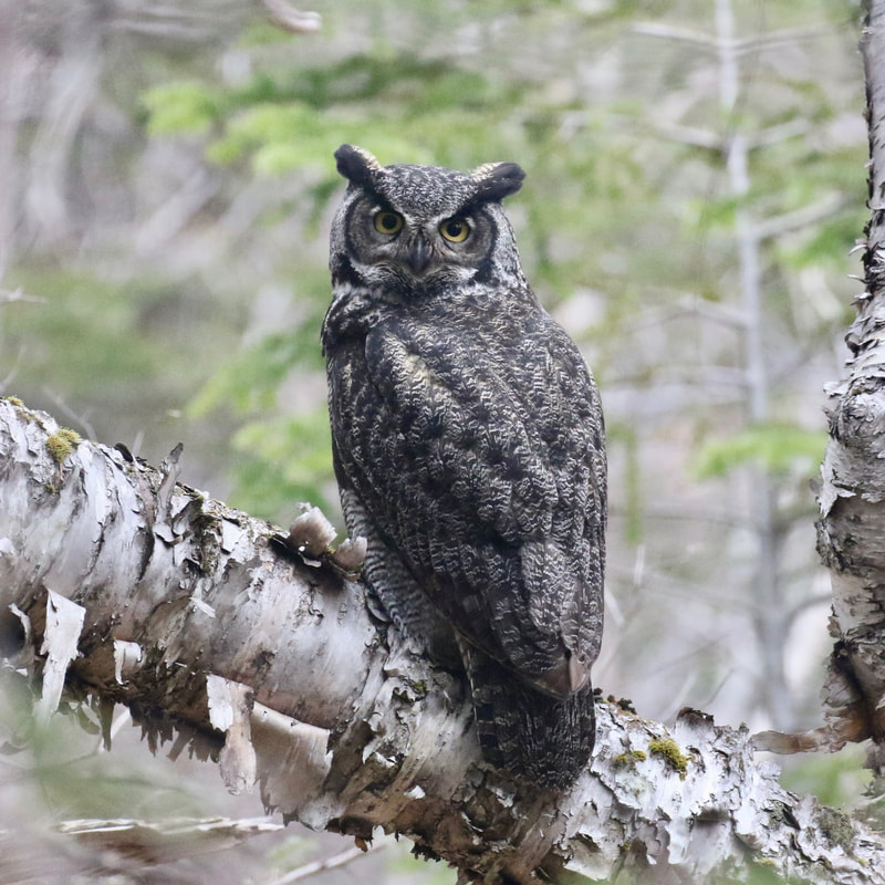
Great Horned Owl. Photo by Alvan Buckley
The Nocturnal Owl Survey provides citizen scientists in NL the chance to contribute to important long-term research for some of the province's most charismatic bird species: owls. 

Owls are top predators and are vulnerable to environmental disturbances such as toxins and habitat loss, making them excellent indicators of environmental health. However, due to their secretive nature and nocturnal habits, they are not well monitored by traditional bird surveys. 

During the Nocturnal Owl Survey, more than 1000 volunteers across Canada spend a spring evening outdoors counting owls. Volunteers sign up to survey one (or more) pre-defined owl survey routes for one night between 1 April and 15 May. Each route consists of 10 stops, separated by 2 kilometers. At each stop, volunteers alternate between timed silent listening periods and playback of owl calls, and record all owls seen or heard.​
​Information on owl populations is essential for developing sound conservation strategies, identifying species in need of conservation action, and evaluating the effectiveness of management programs. The data collected by Nocturnal Owl Survey volunteers ensures that we monitor the distribution, abundance, population trends and habitat associations of these important nocturnal species.

Owl webinar

Watch An Evening of Owls to find out about the owl species found in Newfoundland and Labrador and learn more about the Nocturnal Owl Survey!

IMPORTANT NOTES

  • Survey season runs from 1 April to 15 May each year
  • You can use a portable speaker to play owls calls using the MP3 file below from a phone or alternative device
  • All surveyors must have a NL Gov't permit with them at all times while surveying - you can download the permit below
  • ​Please submit survey results through the Birds Canada NatureCounts website by 15 June​

Volunteer resources

​Click the links below to download documents:
NL Gov't NOS Permit - 2022
Boreal Owl Observation Form
​
NL Nocturnal Owl Survey Instructions
​Nocturnal Owl Survey Data Sheet
​Stop Description Form
Owl Training MP3 file
Owl Broadcast MP3 file

Survey Routes

Survey routes are shown in the above map
​(1) Click the arrow icon in the top left corner of the map.
(2) A legend showing survey routes will appear on the left hand side of the map. 
(3) Re-click the arrow icon to hide the legend.
​

To view a map of available survey routes and sign up for a route, visit the NOS NatureCounts website. (Note: you will have to log in to see route map.) 

To request a new route be mapped out in an area(s) you would like to survey, please email
Catherine Dale (​cdale@birdscanada.org).

MAP of SURVEY ROUTES

Click here to view/explore the map in more detail
​

Route Maps and Coordinates

PDF maps (for use on a GPS enabled device)
​Geo-referenced PDF Maps - Survey Routes - Part 1
​Geo-referenced PDF Maps - Survey Routes - Part 2

Suggested applications:
(1) Avenza PDF Maps
(2) Paper Maps

Note: Geo-referenced PDF maps are not available for all routes. Simple PDF maps (not geo-referenced) can be found on the 
NOS NatureCounts website under Resources.
Excel files of route coordinates (to upload to Google Maps or a handheld GPS)​
  • NL001: Windsor Heights to Pouch Cove
  • NL002: Cataracts
  • NL003: Markland
  • NL004: Goulds to Witless Bay
  • NL005: TNNP to Eastport
  • NL006: TNNP South to North
  • NL007: Flat Rock to Renews
  • NL008: Middle Brook to Dover
  • NL009: Brigus Junction to Bay Roberts
  • NL010: TCH West from Mount Pearl
  • NL011: Tors Cove to Cape Broyle
  • NL012: Logy Bay to Shoe Cove
  • NL013: Paradise to Seal Cove Campus
  • NL014: Port Blandford to Musgravetown
  • NL015: Bloomfield to FSR West
  • NL016: Lethbridge to Southern Bay
  • NL017: TNNP to Town of Terra Nova
  • NL018: Salmonier Line
  • NL019: Stephenville
  • NL020: Pasadena
  • NL021: Humber Valley West
  • NL022: Gander North​
  • NL023: Gander Bay​
  • NL024: Cormack
  • NL025: 430 to Gros Morne
  • NL026: South of Stephenville
  • NL027: Loch Leven Pond
  • NL028: Corner Brook SE
  • NL029: Corner Brook SW
  • NL030: Corner Brook to Meadows
  • NL031: Corner Brook to York Harbour
  • NL032: Newfoundland T'Railway
  • NL033: Holyrood to Marysvale
  • NL034: Kelly's Hill to Fox Steady Resource Road
  • NL035: Cape Spear
  • NL036: Chapel Arm to Argentia Access Rd
  • NL037: Winterton to Brownsdale
  • NL038: Heart's Desire to RR74
  • NL039: Tilton to Hopeall
  • NL040: Witless Bay Line
  • NL041: Chimney Cove to Trout River
  • NL042: Little St. Lawrence to Lewin's Cove
  • NL043: Goobies
  • NL044: Indian Bay Watershed West
  • NL045: Highway 480
  • NL046: Rocky Harbour
  • NL047: Grand Falls-Windsor west
  • NL048: Grand Falls-Windsor south
  • NL049: Grand Falls-Windsor east
  • NL050: New Bay Road
  • NL051: Badger Lake
  • NL052: St. Joseph's to Riverhead
  • NL053: Lomond
  • NL054: Bonavista
  • NL055: Random Island
  • NL056: Salmon Pond
  • NL057: Lewisporte
  • NL058: Fogo Island
  • NL059: St. Alban's
  • NL060: Codroy
  • NL061: Lumsden to Musgrave Harbour
  • NL062: Hatchet Cove
  • NL063: Grand Bank
  • NL064: Hawke's Bay to River of Ponds
  • LAB01: Trans Labrador Highway 500
  • LAB02: Labrador Route 2
  • LAB03: Pinware River Valley
  • LAB04: Route 510
To learn more about this survey across the Atlantic provinces, visit Birds Canada's Atlantic Nocturnal Owl Survey page.
This project is supported by the TD Friends of the Environment Foundation. 
Picture
Picture
Powered by Create your own unique website with customizable templates.